Selected Stargate Manuscripts
- Introduction
- Chapter I - The Discovery Of Stargate
- Chapter V - The Sirius - Dogon Connection
- Chapter VI - To Grok an English Crop Circle
- Chapter XIII - A Different View on the Millenium
- Selected Graphics from the Stargate Manuscripts

Want to learn more?
For access to the complete manuscripts, field research trips, thirty other related ancient sites, individual and team studies of the information accessed from Stargate research, including incoming updated information from related discoveries; seminars & gatherings where the research and studies are transformed into real applications and activities; individual and collective study of the Star Kindred factor; applications for the unique potentials of the Star Kindred; Study of the prime symbols and the sacred alphabets related to communication with our cosmic cousins; transformation of the communication and related studies into various levels of real application, including the original Stargate portal work; plus many other activities too numerous to mention.
Join the Stargate Research team today!
| Chapter VI continued... |
Chapter VI
To Grok an English Crop Circle
Continued...
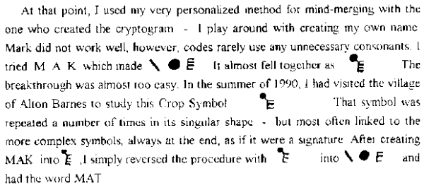
Mat, more often spelled Matt or Maat, is the most ancient Egyptian Goddess of Universal Justice. It should be noted that as with many Egyptian deities, their rule either covered the upper Nile or the lower Nile - Maat is the woman in charge of law and order, not even limited to Egypt, but significantly, the judge of justice of/from the stars.
There are other translations. One is Sekhmet, another Sirius-related Egyptian Goddess. From her past history, I would describe her as the sheriff; the enforcer one would expect to accompany a judge ... There is more to translate, however, at this point I do believe playful locals began to play with the tourists, casting some doubt on the validity of many of the new symbols ... Whatever, I have given you complete translations for every Crop Symbol from 1978 to 1990, and the keys to play with any others that might interest you.
Above all, I believe we have already assembled the major portions of the prime message ... (1) All life is to be honored ... (2) The prime base for the visitors seems to be the Star of Women, in the Sirius system ... (3) They are signaling an end to an era ... and, (4) Their purpose seems to relate to maintaining law and order, and above all, justice in the universe ... I have come across sufficient Egyptian records etc. to assure myself that the extra , 7th judge in the Pleiades council of judges is Sirius ... One last conclusion from my Crop Symbol translations is that whatever the future brings, the era ending may well be the patriarchies , and the future will not be the best of times for male-chauvinists.
One final event sort of tied all the pieces together . As Fate would have it, I just happened to select Whitley Streiber's book, Transformation for the flight home. The book concluded (Appendix three) with research on discovering the "star language" of our cosmic visitors - the alien's native language. >From their studies they concluded the language was a form of Gaelic - the ancestral language of Ireland. And what was the alphabet the Irish used to write down their Gaelic words ? - Ogham!
This is sad to say, but I believe the best years of field research on the Crop Symbols is over. The real is now quite mixed with the fake ... However, there are sufficient unsolved riddles involved with the crop symbol enigma, that there are decades of field research yet to begin - for example, I spent 1989 and 90 in the field, and many an hour since - looking for an answer to a question that had previously only been an adenda to the riddle of the Crop Symbol research ... Why did our cosmic visitors select that one place, in the whole of the planet to place their messages ? I assumed that, after nearly four decades of Megalithic field research, with no small amount within the Crop Symbol area - and extended, live-in archaeological work at an excavation site just to the west of the area - I knew just about all there was to know about the land. It turned out that our cosmic visitors knew the area on a level that I was not even aware of.
To fully describe the following information, I have included two pages of maps (available online). The first map to be referenced will be the green & white map of the Wessex Triangle. First a matter that some of the readership may share with me. My sometimes excessively logical left brain has a very critical mindset that tends to look over my shoulder whenever I am involved in unusual phenomena. Thus, there was an expected mumble from the left brain when I first heard of the Wessex Triangle. It has always bothered that side of me that, whenever strange phenomena is geopraphically mapped out, the shape invariably ends up being a triangle. And my critical side always gives an extra mumble when someone observes that the triangle is quite similar in shape to the Great Pyramid of Giza. Well, this time a "triangle" phenomena was directly involved with my research - so I made a giant map of the area, and spent three nights in the Fall of 1990, placing dots on the map to mark the location of all of the Crop Symbols I had visited or knew of in the past two summers. My some 150 dots virtually redrew the Wessex Triangle and I knew the final effect would have been even more impressive. The most conservative estimate would be that over 200 Crop Symbols appeared within that triangle in the summer of 1990, and nearly that number in the Summer of 1989 - and at the very least, over 100 Crop Symbols from the previous years. And all 500, allowing for an occasional overlap of a few miles, occured within the Triangle. In retrospect, the "why there" question should not have been an adenda ... Indeed, the triangle also included virtually all of the major Megalithic monuments in England. However, if the monuments had been transfered to dots, they would not have made the same neat pattern. All of the major ones are on the West side of the triangle, so there had to be something related to them, but not yet factored in.
Luckily, this aspect of my research came to fruition in the Fall of 1990, when I had lots of spare weekday time on my hands, and the daily appearance/distraction of the Symbols had ceased. The key came one night when I had put aside the Crop Symbol maps and was staring at my old map of the archaeological sites of the area, I had already inked in the boundry of the Wessex Triangle and suddenly noted that the Uffington and Westbury White Horses could have replaced the towns of Wantage & Westbury as two tips of the triangle. I remembered passing by the Marlborough, Alton Barnes and Pewsey White Horses while visiting Crop Symbols. I scanned the map and noted that the only other white horses I knew of in England: Broad Town, Hackpen, and Cherhill, were just on the edge of the triangle ... But first, I must pause to explain to American readers, just what the heck I am talking about. Everyone is quite aware of the Nazca lines and images in South America - some are even aware of similar images in North America - basicly, they are all created by slightly changing the surface of a desert floor. To say the least, they are all rather fragile, and tourism will someday spell their end. Few Americans are aware that England also has giant images that can best be seen by the air. Not to take away from the North & South American images, the English figures took considerably more labour to create. And they were created in the same manner as the Aubrey Holes, which are the prime computer element to Stonehenge.
To create an indelible hole or image, one cuts out the desired shape in the turf and tosses that away - you then dig down thru the top soil until you reach the white chalk, that is from 1 to 6 feet down in that part of England. You then dig thruough the chalk sufficient to create a hole to deposit the top soil in, then place the chalk bottom on the top - and you have created a virtually indelible mark on the land. More so, if you impress the native population with the importance of maintaining the chalk mark so that a folk festival of a yearly cleaning of the space lasts for centuries (as with the Uffington White Horse).
And that is what all those white horses are, giant white horses created with no small effort. The Uffington White Horse is 365 feet long , that is a lot of turf cutting, soil & chalk digging etc. It is assumed that the original
shape of the Uffington horse has been the best preserved of the ancient chalk horses. How ancient ? Well, at first it was assumed to have been created in the first century B.C., for no better reason that the Uffington horse appeared on a first century B.C. Celtic coin. A week before this writing, I noted in my July/August issue of Archaeology (page 24), that archaeological research at the site had redated it to at least 1000 B.C. . There are extra features about the horse that are special. The first is, it doesn't look that much like a horse. Especially, if you add in the local legends, which says they were maintaining an image of a dragon - the legend became somewhat muddled with the advent of Christianity to the land. Legend has it that St. George saved the local Christians from a Dragon - and that it happened on nearby "Dragon Hill" - and the spilled dragon's blood explains why there is a round space on top of the flat topped hill, where no grass will grow. One could rewrite that story quite a bit.
Now, back to that night when I noted the quantity of white horses on the western edge of the Wessex Triangle. Caught up with the moment, I made green circles around each horse site - and an obvious pattern appeared. (You can follow this, on the green & black map of the Wessex Triangle.) As stated before, the Uffington and Westbury horses could serve as the top and left tips of the triangle - a line drawn out from the Cherhill, Alton Barnes, and Pewsey horses can be extended to mark the right tip of the triangle. The Broad Town, Hackpen, and Alton Barnes horses create a line that extends through the three prime Megalithic monuments within the triangle: Avebury, Silbury, & Stonehege. And a line between the Cherhill and Marlborough horses goes right through the Avebury, Silbury site ... This offers a probable conclusion to the "why here". Because those who came in flying "dragons" said they would "return with further instructions".
My left brain didn't just mumble at that conclusion, it virtually shouted, "the rest of the dragons look like horses and are all new!" My archaeologist-prejudice took it from there, to an archaeologist, the 17th & 18th centuries are REALLY new.
Everything seemed to fit except the ages and shapes of the other "horses". So, the following morning, I made a visit to Westbury. Never has my research fallen together so neatly or so quickly. Westbury town records have it that the horse was created by order of the local lord in 1778, because he loved horses, and because the chalk figure already on the hill side that everyone called a "white horse" was such an ugly and distorted image of a horse. A drawing done in 1772, does indeed show something not at all like a horse - in fact, it looked rather like a stylized drawing of a dragon ... Within a week, I was able to ascertain that all of the other "new" horses had equally dubious histories. It is more than logical to now assume that the "new" histories all have missing first chapters .
With potential critics around every ancient UFO conclusion, I must add a bit more to the matter of England's chalk figures. Yes, there is a giant chalk figure called the Cerne Abbas Giant in Dorset. Locals love to show the 180 foot tall chalk figure to little old lady tourists. It is truly rude. The erect phallus, considerably out of proportion, is the most obvious feature of the figure. Historians have always been bemused by the figure which apparently stood for so long in the near vicinity of a monestary that was created in the 6th century. Well, the man most responsible for attaching metaphysics (in the form of dowsing) to my archaeological studies, T.C. Lethbridge, studied the figure and concluded that the area had been seriously re-drawn. In fact, local history has it that, yet another local lord had been doing a bit of redrawing of local history. A certain Lord Holles (1641 to 1666) either created or recut the image. Either way, he was a very perverse artist - and he and his kind almost confused some critical mesages from the past.
While on the subject of Tom Lethbridge, my first instructor in Archaeology - and giant chalk figures. He managed to find the remnants of three human figures and a horse and chariot in the hills near Cambridge. His interpretation of the scene was ... that "originally there was only Magog (she was 120 feet high) with the horse and chariot, cut around 200 B.C. , and that the other two male figures were added later, around 50 B.C." The site has been allowed to be overgrown, which is quite sad. Maybe you can find a copy of the Janet & Colin Bord's book, Mysterious Britain, it has a good photograph of Ms. Magog - the most noticeable feature of the woman is her face, with two very large eyes.
The Bord's chapter on chalk figures is entitled, "Hill Figures: Signals to the Gods?"... which reminded me of the most interesting of all of England's chalk figures. If you are interested in ancient earth to sky symbols, you are no stranger to the remarkable Candelabra of the Andes, the 840 foot high trident set on the coast, pointing the way to the Nazca line and images ... Well, on the Southern Coast of England, there is also an image that I perceive as a direction guide to the chalk signals beyond. The figure is 230 feet long. And has managed to retain its original shape, there was work on the figure in 1874, but this time, the local history carries the all important word "restored". Any
changes were limited to the mind (rather than the actual chalk figure) - yes, we have returned to yet another example of "if the individual is important, it is a man" mind-set of patriarchal societies. The chalk figure is known as the "Long Man of Wilmington - it is near the town of Wilmington in Sussex. Seen from the ground, as I have on several occasions, it not only offer no specific clue as to gender, the shape always seemed somewhat feminine in form. The drawing to the right is a depiction drawn from an arial photograph - from this angle, I cannot but observe that the form is female - and possibly, a full figure study of a lady from the Pleiades. It certainly looks closer to one of the figures stepping out of the Mother Ship in Encounters of the Third Kind, than the standard depiction of a Neolithic human, male or female. And that is the era, the Neolithic, most scholars place as the creation time for the remarkable chalk figure.
Now, we return to the maps, the third one, marked, The Silbury Triangle ... When I made the dot map to verify the Wessex Triangle - I discovered yet another triangle. (The left side of my brain went into total shock, it was directly responsable for bringing yet another triangle/pyramid phenomena into the legends of the metaphysical realm). As the dot work progressed, in one specific area, I first began to place dots on top of dots - then set an outside area for the extra dots. Finally, I created a table size map of an area 7 X 7 X 7 miles in size (the Wessex Triangle has sides 40 miles long. Within the small triangle, which I named the Silbury Triangle, over 50 Crop Symbols appeared in the summer of 1990 and many of them were the most dramatic of the Symbols, one of which was this one - from which I managed to translate the words, Tuatha De - I will leave this one as an armchair riddle for the cryptographers among the readers. This Crop Symbol , as well as a number of other, equally complex examples of the phenomena, appeared to be pointing at Silbury Hill. Which, if you consider Silbury as a symbol of Dana, we have the completion to the symbol's phrase.
I focused more research on my personal triangle, over 50 Crop Symbols had occured within it in 1989, and in 1988. And, within this small triangle of space, are found the most special of England's Megalithic monuments. At the top of the triangle is Avebury, a stone circle that - I will let John Aubrey's words describe it, written 300 years ago, he said it better than I will ever be able to ... "Avebury doth as much exceed Stonehenge in grandeur as a Cathedral doth an ordinary Parish Church." ... Today, little of Avebury's past grandeur remains. Cleric-led mobs in the 17th & 18th centuries smashed most of the giant stones to pieces. Now only 27 sarsen stones, weighing up to 40 tons remain. Originallay, there were 100. The giant stone circle, already ancient, when Stonehenge was in its infancy, was enclosed by an earth bank and ditch 1,300 feet in diameter. The ditch was 30 feet deep, from the bottom of the ditch to the top of the bank is 55 feet - a lot of work to contain the ritual energy within. Within the giant stone ring and earthwork lay two smaller circles, each containing 30 lesser monoliths - these fell prey to the construction of the small village that lies within the monument. Also, little remains of the two avenues of stone, 50 feet wide and 78 each a mile and a half long, extending out from Avebury - creating, when viewed from the air, the headress of Sekhmet. It has been estimated that this great monument was comprised of 600 stone monoliths - now, virtually obliterated by religious fanaticism and the avarice of local builders. A fate which gives the wisdom of foresight to the creators of the second stage of the construction of Silbury Hill.
Luckily, when Avebury was being systamaticly destroyed, Silbury was only perceived as a hill - and ignored. Antiquitarians noted that Silbury had a rather unnatural conical shape for a hill - and the ditch and bank surrounding it offered a clue that it could be a truely giant man-made earth mound ... Over the centuries, researchers connected the shape of the hill to legends linking it with the Earth-Mother and/or the Universal-Creatrix. As sanity and insight returned to the land, it was also observed how Silbury differed considerably from other man-made earth mounds around the world. It has the form of a huge flat-topped cone, covering over five acres at its base, with a height of 130 feet. The sides have a remarkably uniform slope of about 30 degrees. With extended study and the addition of arial photography, an equally uniform, identing effect (like a shelf) was observed near the top - with that information, more evidence of inner shelves were discovered. The shelf information was merged with information obtained from several centuries of tunnel and shaft excavations, in search of treasure. A major tunnel excavation was lead by the Egyptologist Sir Flinders Petrie in 1922 - I would guess that, to take a year apart from Egyptian excavations in their peak era, he sensed more about the matter than he cared to share. All shafts and tunnels encountered hard packed chalk just beyond the top soil - logical in that area, when digging down - most illogical when digging into something man-made.
Finally, within recent years, with test digs along the slope - it has been discovered that Silbury was not an earth mound - it is a conical, step pyramid built of chalk stone - that was covered with earth at a second stage of work. Carbon studies on artifacts found within the step pyramid place its orignal creation at a time before the building of Egypt's step pyramid , which was a forerunner, by centuries, of the more famous pyramids, such as Giza ... Pyramidologists should take note, and remember that, the energy spiral within a pyramid is in the shape of a cone. The now understood form of the real Silbury matches that spiral cone of energy perfectly - stand on top of Silbury, and you have no need of archaeological evidence to feel the final effect.
| |
Chapter
VI continued... |

Stargate Site Guide
- Stargate Bookstore Online
- Stargate Blog
- Star Seed Quiz
- Stargate research conclusions
- Free Stargate manuscript pages
- Stargate research regarding the millenium
- Research connections to ancient Egypt
- Manuscript graphics
- Ogham Alphabet that appears in the manuscript
- Connections between ancient Ireland, the
ancient Dravidian culture of India, the Matriarchies, Tantra, the
Pleiades.
- Mark Roberts Biography
- Join the Stargate Research team
- Additional Stargate Sites
- Email Us